
Rising Environmental Vulnerability in the Himalayas
Rising human settlements, expanding hydroelectric projects, and increasing tourism apart from climate change are placing immense pressure on fragile hill ranges. Combined with the accelerating impacts of climate change, these factors significantly heighten the risk of severe disasters—such as the Bhote Koshi and Trisuli floods—across the Himalayas, particularly in Nepal, India, and China.
Infrastructure Expansion: Construction of hydroelectric plants and roads destabilizes vulnerable slopes. Demographic Pressure: Unplanned human settlements increase population exposure in high-risk zones. Unregulated Tourism: Heavy foot traffic and tourist infrastructure exacerbate localized environmental strain. Climate Amplification: Changing weather patterns and extreme rainfall trigger frequent flash floods and landslides.
Nepal scenario
Over the past decade (2016–2026), Nepal’s complex Himalayan geography—characterized by steep terrain, active tectonic fault lines, and climate-induced glacial shifts—has made it one of the most disaster-prone regions in the world for river cascades, landslides, and outburst floods. While Nepal experiences thousands of minor localized natural events annually (the National Disaster Risk Reduction and Management Authority recorded over 32,000 disaster events between 2018 and 2024 alone), roughly 10 to 12 major, high-impact river and mountain disaster incidents similar in scale and dynamics to the Bhote Koshi and Trishuli river calamities have occurred over the last ten years.
Natural calamities in Tibet and China
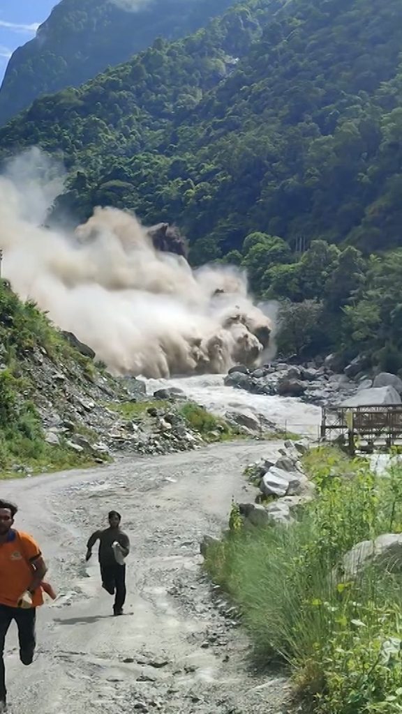
Ten major natural calamities took place in Tibet and other areas controlled by China. These disasters involved cascading hazards—such as Glacier Collapses, Glacial Lake Outburst Floods (GLOFs), and Landslide Dam Outburst Floods (LDOFs)—striking major river basins including the Bhote Koshi, Trishuli, Sunkoshi, and Marsyangdi systems.
August 2026 (Bhote Koshi / Trishuli River Glacier Collapse & Flash Flood): A massive chunk of glacier ice and rock high up near the Nepal-China border collapsed into the Lhende Khola/Bhote Koshi basin, generating an equivalent magnitude 5.2 seismic event.
July 2020 – Gonghai Lake GLOF (Poiqu / Bhote-Koshi River): A glacial lake in Nyalam County, Tibet, breached its natural moraine dam following heavy monsoon rain and ice avalanches. The surge traveled down the Poiqu–Bhote Koshi channel, damaging the Araniko Highway, destroying border infrastructure, and threatening hydel power installations.
July 2016 – Gonghai / Zhangzangbo Outburst Flood (Bhote-Koshi Basin): A glacial lake outburst in the upper Tibetan catchments of the Poiqu/Bhote Koshi River released over 10 million cubic meters of water. The surge destroyed the Friendship Bridge connecting China and Nepal, damaged the Upper Bhote Koshi Hydropower Project, and washed away extensive sections of the highway.
October 2018 – Yarlung Zangbo / Brahmaputra Landslide Dams: Further east in the Tibetan Himalayan belt (Mainling County), massive rockfalls and landslides twice blocked the Yarlung Zangbo River, creating barrier lakes that posed immense outburst flood risks to downstream communities in India.
Extreme Events in India
India experiences dozens of major weather- and climate-induced extreme events each year. However, if we look specifically at catastrophic landslides, flash floods, and cloudburst-triggered slope collapses similar in nature and scale to the July 2024 Wayanad disaster, India has witnessed approximately 12 to 15 major high-fatality incidents over the past decade. In addition to these major events, official records from the Geological Survey of India (GSI) document over 2,000 to 3,000 localized, small-to-medium landslide occurrences across fragile terrains like the Western Ghats and the Himalayas during monsoon seasons.
Wayanad Disaster
Over the past decade (2014–2024), India has witnessed a recurring series of catastrophic landslides, flash floods, and debris flows that closely mirror the scale and nature of the 2024 Wayanad disaster. The trend began in July 2014 when torrential monsoon rains caused a massive hillside collapse in Malin, Maharashtra, killing roughly 151 people and burying an entire village. Late the following year, the 2015 Chennai floods claimed over 500 lives due to unprecedented rainfall combined with extreme urban drainage failures. Monsoon instability intensified in 2018 when Kerala experienced its worst deluge in a century, triggering hundreds of landslides state-wide and resulting in more than 480 deaths.
Extreme weather and fragile slope failures spread rapidly across other eco-sensitive regions as well. In February 2021, a rock and ice avalanche in Chamoli, Uttarakhand, unleashed severe flash floods down the Rishiganga river, causing over 200 fatalities or missing persons, while later that October, cloudburst-like rains caused multiple hill slides across Koottickal and Kokkayar in Kerala, killing about 25 people.
Common Factors Driving These Calamities
Extreme Rainfall Events: Shift from distributed monsoon showers to intense, localized downpours (over 200–500 mm in 24 hours) due to Arabian Sea and Bay of Bengal warming. Ecological Vulnerability: Eco-fragile zones in the Western Ghats and the Himalayas facing terrain alteration, deforestation, and monoculture plantations. Soil Saturation Thresholds: Prolonged antecedent rain saturates topsoil, making steep slopes prone to catastrophic fluidization and mudflows.

Editor, Prime Post
Ravindra Seshu Amaravadi, is a senior journalist with 38 years of experience in Telugu, English news papers and electronic media. He worked in Udayam as a sub-editor and reporter. Later, he was associated with Andhra Pradesh Times, Gemini news, Deccan Chronicle, HMTV and The Hans India. Earlier, he was involved in the research work of All India Kisan Sabha on suicides of cotton farmers. In Deccan Chronicle, he exposed the problems of subabul and chilli farmers and malpractices that took place in various government departments.
Email: ravindraseshu7@gmail.com
Mobile: 9063718675